
Bamberg
Kettenbrücke, 96052 Bamberg, Deutschland
Chain Bridge Bamberg | Photos & Directions
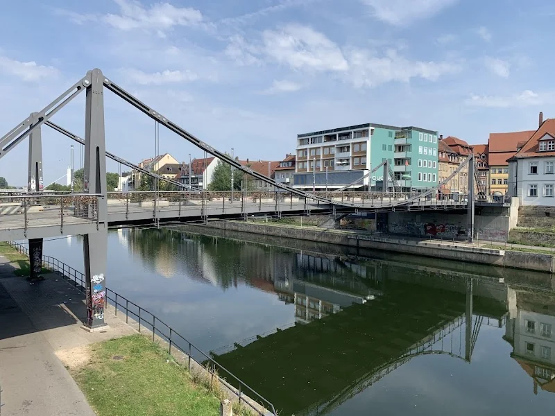
The Chain Bridge in Bamberg is much more than a simple crossing over the river: it is a place where city history, transportation routes, and today's everyday life in the Bamberg center meet. At the same location stood the Sees Bridge, which was mentioned in the 13th century and was rebuilt in the 18th century as a baroque stone bridge with great effort. The current Chain Bridge is part of a long series of bridge constructions that span the right arm of the Regnitz at one of the most important points in the city. ([stadt.bamberg.de](https://www.stadt.bamberg.de/media/custom/3481_3662_1.PDF?1694107985=))
Location of the Chain Bridge in Bamberg and Orientation on the Map
Those searching for Chain Bridge Bamberg Maps usually want not an abstract theory, but a clear orientation in the center. The bridge is ideal for this: it connects the Hauptwachstraße with the Kettenbrückstraße and crosses the right arm of the Regnitz, which is also part of the Main-Danube Canal here. In this location, it lies in the urban structure of the city center and forms an important transition between the main routes of the old town. The city of Bamberg describes the area around the Chain Bridge, Kettenbrückstraße, Hauptwachstraße, and Heinrichsdamm as a space that has been newly organized and upgraded with the construction of the bridge. ([de.wikipedia.org](https://de.wikipedia.org/wiki/Kettenbr%C3%BCcke_%28Bamberg%29))
For this reason, the Chain Bridge is not only a traffic structure but also a visual anchor point. Those walking in Bamberg quickly orient themselves by bridges, waterways, and the historical axes of the city. The bridge is located in the vicinity of the pedestrian zone around Maximiliansplatz and thus in an area where many paths converge. This also explains why so many search queries target photos, maps, and location questions: the Chain Bridge is a point where one can mentally organize the city. For visitors, this is helpful because from here the city center, the adjacent neighborhoods, and the paths along the Regnitz can be easily accessed. ([de.wikipedia.org](https://de.wikipedia.org/wiki/Kettenbr%C3%BCcke_%28Bamberg%29))
The city itself describes Bamberg as a city of short distances, where many things can be easily reached on foot or by bicycle. This fits perfectly with the Chain Bridge: it is an urban hub, not a remote destination. Those who arrive are practically already in the center of the action. Therefore, the bridge is an excellent starting point for city walks, for first photos, and for orientation on the way to the surrounding squares, streets, and sights. So, when searching for the Chain Bridge on a map, one is not just looking for a single structure but a central access point to the cityscape of Bamberg. ([stadt.bamberg.de](https://www.stadt.bamberg.de/Leben/Verkehr-und-Infrastruktur/index.php?utm_source=openai))
History from the Sees Bridge to the Present Chain Bridge
The history of this place dates back surprisingly far. The city archive reports that Emperor Henry II mentioned a bridge in 1020 that framed the reception on both sides of the river; a documented mention of the Sees Bridge is secured for the year 1312. The appearance and construction of the early bridge are not fully preserved, but sources make it clear that it was initially a wooden bridge that had to be repaired repeatedly. It was not until 1602 that it was depicted, resting on five piles and equipped with protective devices against ice and driftwood. In the Baroque period, Prince-Bishop Johann Philipp Anton von Franckenstein commissioned a representative stone bridge designed by Balthasar Neumann, which was opened in 1752. It was part of a baroque axis from Steinweg, now Königsstraße, up to the Cathedral Hill. ([stadt.bamberg.de](https://www.stadt.bamberg.de/media/custom/3481_3662_1.PDF?1694107985=))
However, the baroque bridge was destroyed in 1784 by an exceptionally strong flood. After that, there were temporary solutions and finally, in 1809, a new wooden structure by engineer Karl Friedrich von Wiebeking, which spanned the river without supports over 71 meters. This structure also did not withstand the test of time and was demolished in 1826. Then came the probably most famous predecessor of the current bridge: the iron Chain Bridge of 1829, built by Bamberg district engineer Franz Joseph Schierlinger after a model in the Bohemian town of Saaz. Its intended portals were replaced by pylons based on a design by Leo von Klenze. Officially it was called Ludwig Bridge, but in common parlance, the name Chain Bridge prevailed. The exhibition of the city archive also points out that John August Roebling later used this Bamberg bridge as a model for the Brooklyn Bridge in New York. ([stadt.bamberg.de](https://www.stadt.bamberg.de/media/custom/3481_3662_1.PDF?1694107985=))
After the Chain Bridge of 1829, an iron arch bridge followed in 1892, which was blown up in World War II in 1945. During the provisional phase, a pedestrian bridge maintained the connection between the island city and the eastern district, later a frame bridge took over the traffic in 1953. This bridge also showed significant damage after decades, making a new construction inevitable. In connection with the bridge project in 2010, a competition was announced across Europe; the city documented not only technical but also design and heritage conservation questions. The new Chain Bridge was constructed in 2009 and 2010. This closes an unusually dense sequence of bridge epochs at this location, which is rarely so clearly discernible in Bamberg. ([stadt.bamberg.de](https://www.stadt.bamberg.de/media/custom/3481_3662_1.PDF?1694107985=))
This continuity makes the Chain Bridge historically interesting. It is not an isolated individual structure but the result of centuries of engagement with the same spot on the river. Floods, technical innovations, urban changes, and the significance of the World Heritage status have repeatedly shaped the site. Therefore, when one sees the bridge today, one perceives not only the current construction but also stands at a place where medieval, baroque, industrial, and contemporary city history overlap. The name Chain Bridge is thus more than a designation: it is a memory anchor for the development of Bamberg by the water. ([stadt.bamberg.de](https://www.stadt.bamberg.de/media/custom/3481_3662_1.PDF?1694107985=))
Directions and Parking around the Chain Bridge
For directions to the Chain Bridge, it is worth taking a look at the official traffic situation of the city. Bamberg is located on the A73 Nuremberg-Coburg and the A70 Schweinfurt-Bayreuth; signs on the access roads point to the Park & Ride facilities or parking options in the city center. The tourism page of the city generally recommends using Park & Ride from Monday to Saturday, as this allows access to the city center without long searches for a parking space. This is particularly sensible for the Chain Bridge, as it is located in a densely frequented city center area where parking space is scarce and traffic management can change depending on construction sites. Those who want to pay attention to current closures can find them on the continuously maintained traffic pages of the city of Bamberg. ([bamberg.info](https://www.bamberg.info/anreise/))
However, those who still want to park directly in the city center will find a whole range of options on the tourism page. These include, among others, the underground parking garage Maximiliansplatz, the underground parking garage City-Altstadt, the underground parking garage Zentrum-Nord, the parking lot Altes Hallenbad, and the parking lot Schillerplatz. Additionally, Bamberg Tourism lists Park & Ride offers such as Bahnhof/Brennerstraße, Heinrichsdamm, and Kronacher Straße. For visitors to the Chain Bridge, this is practical because depending on the time of day, duration of stay, and route, a suitable solution can be found. Those who are only briefly on site can move closer to the old town; those who want to arrive more stress-free can park at a P&R facility and walk the rest on foot. ([bamberg.info](https://www.bamberg.info/parkplaetze/))
The best recommendation remains the combination of walking, cycling, and public transport. Bamberg describes itself as a city of short distances, and the tourist arrival page points out that much can be easily reached on foot or by bicycle within the city. For cyclists, there are signposted routes in the urban area, and orientation and route guidance are also well developed in the city center. So, those who want to go to the Chain Bridge do not necessarily need a car. Especially for a short visit, for photos, or for a city walk, it is often more pleasant to arrive near a parking garage or a P&R facility and walk the last section leisurely on foot. This way, one experiences the historical density of the center better than from a car. ([stadt.bamberg.de](https://www.stadt.bamberg.de/Leben/Verkehr-und-Infrastruktur/index.php?utm_source=openai))
Another advantage of the inner-city location: the Chain Bridge can be easily combined with other destinations. For example, those coming from the train station, Maximiliansplatz, or the pedestrian zone can reach the bridge via relatively short paths. This makes it interesting for day visitors who do not want to spend the whole day in Bamberg but only want to experience a concise section of the old town. For such visits, the combination of P&R, a short walk, and a clear orientation point is particularly valuable. Exactly for this purpose, the Chain Bridge is suitable: it is easy to find, central, and integrated into the urban traffic structure. ([bamberg.info](https://www.bamberg.info/parkplaetze/))
Bridge Construction, Design, and Urban Significance
The construction of the Chain Bridge was treated with great care not only technically but also in terms of design. The city documentation describes that the new bridge was advertised across Europe in connection with the bridge project 2010, and the architectural impact on the World Heritage site received special attention. A design for a suspension bridge was ultimately selected. Thus, the current bridge connects to the historical typology of chain bridges without simply copying its construction. For Bamberg, it was important that the bridge is built at a sensitive point in the urban structure and simultaneously strengthens the connection between the adjacent areas. ([stadt.bamberg.de](https://www.stadt.bamberg.de/media/custom/3481_3662_1.PDF?1694107985=))
Therefore, the city not only planned the structure itself but also its surroundings anew. On the official page for the Chain Bridge, it states that the areas Kettenbrückstraße, Hauptwachstraße, Vorderer Graben, and Heinrichsdamm should be upgraded in the course of the bridge's reconstruction. This included questions of paving, lighting, and furnishing with benches and waste bins. The space between the bridge, street, and pedestrian zone was thus conceived as a coherent urban piece, not merely as a traffic area. This is typical for Bamberg: the cityscape is not only determined by individual monuments but by finely tuned transitions between water, path, square, and architecture. ([stadt.bamberg.de](https://www.stadt.bamberg.de/?object=tx%7C2730.2114.1&utm_source=openai))
Urbanistically, the Chain Bridge thus has a dual function. On the one hand, it is infrastructure because it organizes movement and accessibility. On the other hand, it is part of the historical urban space, which stands in the context of UNESCO and in which every change is perceived particularly sensitively. The area belongs to the core of the old town, which defines Bamberg as a World Heritage city. So, those standing here see not only a bridge but a junction of history, traffic, urban design, and tourism. For this reason, the debates surrounding the new construction, design, and surroundings in Bamberg have played such a significant role for years. ([stadt.bamberg.de](https://www.stadt.bamberg.de/Unsere-Stadt/Stadtinfo/Stadtportr%C3%A4t/?utm_source=openai))
For visitors, this is particularly interesting because the bridge should not be viewed in isolation. Its effect only arises through its embedding in the water, in the adjacent streets, and in the sight lines of the old town. The Chain Bridge is thus a good example of how Bamberg continually connects its historical substance with contemporary solutions. This mixture of continuity and renewal makes the place exciting for architecture enthusiasts and city photographers. Those interested in building culture will find at the Chain Bridge not only a beautiful motif but also a vivid piece of urban development. ([stadt.bamberg.de](https://www.stadt.bamberg.de/media/custom/3481_3662_1.PDF?1694107985=))
Walks, City Tours, and Photo Opportunities at the Chain Bridge
The Chain Bridge is an ideal meeting point for walks, tours, and light city explorations. Bamberg Tourism names the bridge as a meeting point for Running City Tours, which combine running and sightseeing. This shows that the bridge not only functions as a traffic area but also as a clear starting and orientation point for experiences in the city center. Those who start here quickly reach the most important paths and can perceive the city from the perspective of the water and the old town at the same time. ([bamberg.info](https://www.bamberg.info/veranstaltungen/sportliche_stadtfuehrung_runni-541697/?utm_source=openai))
The location is also favorable for classic city routes. The VGN describes in its city tour through Bamberg that one reaches Maximiliansplatz over the Chain Bridge, which is considered the most important and largest square in the city center. This makes the bridge a link between the water area and the urban center. For visitors, this is practical because many other destinations can be accessed from here without having to plan complicated routes. Especially if one only has half a day in the city, a clear focal point like the Chain Bridge is particularly valuable. ([vgn.de](https://www.vgn.de/staedtetouren/bamberg/?utm_source=openai))
Those looking for photos will quickly find what they are looking for at the Chain Bridge. The location by the river, the historical depth of the site, and the proximity to the old town create strong image motifs that work both during the day and at dusk. Official tourism images, image collections, and historical documentation repeatedly show the bridge as a striking element of the Bamberg cityscape. This is no coincidence, as at hardly any other place can one see how closely water, architecture, and city history are interconnected in Bamberg. For social media, travel blogs, or private memory photos, the bridge is therefore a natural stop. ([medienportal.bamberg.info](https://medienportal.bamberg.info/?utm_source=openai))
Also, those who want to experience Bamberg not just photograph it benefit from this location. The Chain Bridge is a place to arrive, continue, and return. It marks not only a crossing over the Regnitz but also the transition between historical districts, shopping paths, walking routes, and tourist routes. Thus, a seemingly small point on the map becomes a significant part of the entire city experience. This is exactly what makes the Chain Bridge Bamberg so interesting for visitors: it is easily accessible, historically charged, and simultaneously anchored in today's urban life. ([de.wikipedia.org](https://de.wikipedia.org/wiki/Kettenbr%C3%BCcke_%28Bamberg%29))
Sources:
The following official and professional pages were used for the content. ([stadt.bamberg.de](https://www.stadt.bamberg.de/media/custom/3481_3662_1.PDF?1694107985=))
Mehr anzeigenWeniger anzeigen
Chain Bridge Bamberg | Photos & Directions
The Chain Bridge in Bamberg is much more than a simple crossing over the river: it is a place where city history, transportation routes, and today's everyday life in the Bamberg center meet. At the same location stood the Sees Bridge, which was mentioned in the 13th century and was rebuilt in the 18th century as a baroque stone bridge with great effort. The current Chain Bridge is part of a long series of bridge constructions that span the right arm of the Regnitz at one of the most important points in the city. ([stadt.bamberg.de](https://www.stadt.bamberg.de/media/custom/3481_3662_1.PDF?1694107985=))
Location of the Chain Bridge in Bamberg and Orientation on the Map
Those searching for Chain Bridge Bamberg Maps usually want not an abstract theory, but a clear orientation in the center. The bridge is ideal for this: it connects the Hauptwachstraße with the Kettenbrückstraße and crosses the right arm of the Regnitz, which is also part of the Main-Danube Canal here. In this location, it lies in the urban structure of the city center and forms an important transition between the main routes of the old town. The city of Bamberg describes the area around the Chain Bridge, Kettenbrückstraße, Hauptwachstraße, and Heinrichsdamm as a space that has been newly organized and upgraded with the construction of the bridge. ([de.wikipedia.org](https://de.wikipedia.org/wiki/Kettenbr%C3%BCcke_%28Bamberg%29))
For this reason, the Chain Bridge is not only a traffic structure but also a visual anchor point. Those walking in Bamberg quickly orient themselves by bridges, waterways, and the historical axes of the city. The bridge is located in the vicinity of the pedestrian zone around Maximiliansplatz and thus in an area where many paths converge. This also explains why so many search queries target photos, maps, and location questions: the Chain Bridge is a point where one can mentally organize the city. For visitors, this is helpful because from here the city center, the adjacent neighborhoods, and the paths along the Regnitz can be easily accessed. ([de.wikipedia.org](https://de.wikipedia.org/wiki/Kettenbr%C3%BCcke_%28Bamberg%29))
The city itself describes Bamberg as a city of short distances, where many things can be easily reached on foot or by bicycle. This fits perfectly with the Chain Bridge: it is an urban hub, not a remote destination. Those who arrive are practically already in the center of the action. Therefore, the bridge is an excellent starting point for city walks, for first photos, and for orientation on the way to the surrounding squares, streets, and sights. So, when searching for the Chain Bridge on a map, one is not just looking for a single structure but a central access point to the cityscape of Bamberg. ([stadt.bamberg.de](https://www.stadt.bamberg.de/Leben/Verkehr-und-Infrastruktur/index.php?utm_source=openai))
History from the Sees Bridge to the Present Chain Bridge
The history of this place dates back surprisingly far. The city archive reports that Emperor Henry II mentioned a bridge in 1020 that framed the reception on both sides of the river; a documented mention of the Sees Bridge is secured for the year 1312. The appearance and construction of the early bridge are not fully preserved, but sources make it clear that it was initially a wooden bridge that had to be repaired repeatedly. It was not until 1602 that it was depicted, resting on five piles and equipped with protective devices against ice and driftwood. In the Baroque period, Prince-Bishop Johann Philipp Anton von Franckenstein commissioned a representative stone bridge designed by Balthasar Neumann, which was opened in 1752. It was part of a baroque axis from Steinweg, now Königsstraße, up to the Cathedral Hill. ([stadt.bamberg.de](https://www.stadt.bamberg.de/media/custom/3481_3662_1.PDF?1694107985=))
However, the baroque bridge was destroyed in 1784 by an exceptionally strong flood. After that, there were temporary solutions and finally, in 1809, a new wooden structure by engineer Karl Friedrich von Wiebeking, which spanned the river without supports over 71 meters. This structure also did not withstand the test of time and was demolished in 1826. Then came the probably most famous predecessor of the current bridge: the iron Chain Bridge of 1829, built by Bamberg district engineer Franz Joseph Schierlinger after a model in the Bohemian town of Saaz. Its intended portals were replaced by pylons based on a design by Leo von Klenze. Officially it was called Ludwig Bridge, but in common parlance, the name Chain Bridge prevailed. The exhibition of the city archive also points out that John August Roebling later used this Bamberg bridge as a model for the Brooklyn Bridge in New York. ([stadt.bamberg.de](https://www.stadt.bamberg.de/media/custom/3481_3662_1.PDF?1694107985=))
After the Chain Bridge of 1829, an iron arch bridge followed in 1892, which was blown up in World War II in 1945. During the provisional phase, a pedestrian bridge maintained the connection between the island city and the eastern district, later a frame bridge took over the traffic in 1953. This bridge also showed significant damage after decades, making a new construction inevitable. In connection with the bridge project in 2010, a competition was announced across Europe; the city documented not only technical but also design and heritage conservation questions. The new Chain Bridge was constructed in 2009 and 2010. This closes an unusually dense sequence of bridge epochs at this location, which is rarely so clearly discernible in Bamberg. ([stadt.bamberg.de](https://www.stadt.bamberg.de/media/custom/3481_3662_1.PDF?1694107985=))
This continuity makes the Chain Bridge historically interesting. It is not an isolated individual structure but the result of centuries of engagement with the same spot on the river. Floods, technical innovations, urban changes, and the significance of the World Heritage status have repeatedly shaped the site. Therefore, when one sees the bridge today, one perceives not only the current construction but also stands at a place where medieval, baroque, industrial, and contemporary city history overlap. The name Chain Bridge is thus more than a designation: it is a memory anchor for the development of Bamberg by the water. ([stadt.bamberg.de](https://www.stadt.bamberg.de/media/custom/3481_3662_1.PDF?1694107985=))
Directions and Parking around the Chain Bridge
For directions to the Chain Bridge, it is worth taking a look at the official traffic situation of the city. Bamberg is located on the A73 Nuremberg-Coburg and the A70 Schweinfurt-Bayreuth; signs on the access roads point to the Park & Ride facilities or parking options in the city center. The tourism page of the city generally recommends using Park & Ride from Monday to Saturday, as this allows access to the city center without long searches for a parking space. This is particularly sensible for the Chain Bridge, as it is located in a densely frequented city center area where parking space is scarce and traffic management can change depending on construction sites. Those who want to pay attention to current closures can find them on the continuously maintained traffic pages of the city of Bamberg. ([bamberg.info](https://www.bamberg.info/anreise/))
However, those who still want to park directly in the city center will find a whole range of options on the tourism page. These include, among others, the underground parking garage Maximiliansplatz, the underground parking garage City-Altstadt, the underground parking garage Zentrum-Nord, the parking lot Altes Hallenbad, and the parking lot Schillerplatz. Additionally, Bamberg Tourism lists Park & Ride offers such as Bahnhof/Brennerstraße, Heinrichsdamm, and Kronacher Straße. For visitors to the Chain Bridge, this is practical because depending on the time of day, duration of stay, and route, a suitable solution can be found. Those who are only briefly on site can move closer to the old town; those who want to arrive more stress-free can park at a P&R facility and walk the rest on foot. ([bamberg.info](https://www.bamberg.info/parkplaetze/))
The best recommendation remains the combination of walking, cycling, and public transport. Bamberg describes itself as a city of short distances, and the tourist arrival page points out that much can be easily reached on foot or by bicycle within the city. For cyclists, there are signposted routes in the urban area, and orientation and route guidance are also well developed in the city center. So, those who want to go to the Chain Bridge do not necessarily need a car. Especially for a short visit, for photos, or for a city walk, it is often more pleasant to arrive near a parking garage or a P&R facility and walk the last section leisurely on foot. This way, one experiences the historical density of the center better than from a car. ([stadt.bamberg.de](https://www.stadt.bamberg.de/Leben/Verkehr-und-Infrastruktur/index.php?utm_source=openai))
Another advantage of the inner-city location: the Chain Bridge can be easily combined with other destinations. For example, those coming from the train station, Maximiliansplatz, or the pedestrian zone can reach the bridge via relatively short paths. This makes it interesting for day visitors who do not want to spend the whole day in Bamberg but only want to experience a concise section of the old town. For such visits, the combination of P&R, a short walk, and a clear orientation point is particularly valuable. Exactly for this purpose, the Chain Bridge is suitable: it is easy to find, central, and integrated into the urban traffic structure. ([bamberg.info](https://www.bamberg.info/parkplaetze/))
Bridge Construction, Design, and Urban Significance
The construction of the Chain Bridge was treated with great care not only technically but also in terms of design. The city documentation describes that the new bridge was advertised across Europe in connection with the bridge project 2010, and the architectural impact on the World Heritage site received special attention. A design for a suspension bridge was ultimately selected. Thus, the current bridge connects to the historical typology of chain bridges without simply copying its construction. For Bamberg, it was important that the bridge is built at a sensitive point in the urban structure and simultaneously strengthens the connection between the adjacent areas. ([stadt.bamberg.de](https://www.stadt.bamberg.de/media/custom/3481_3662_1.PDF?1694107985=))
Therefore, the city not only planned the structure itself but also its surroundings anew. On the official page for the Chain Bridge, it states that the areas Kettenbrückstraße, Hauptwachstraße, Vorderer Graben, and Heinrichsdamm should be upgraded in the course of the bridge's reconstruction. This included questions of paving, lighting, and furnishing with benches and waste bins. The space between the bridge, street, and pedestrian zone was thus conceived as a coherent urban piece, not merely as a traffic area. This is typical for Bamberg: the cityscape is not only determined by individual monuments but by finely tuned transitions between water, path, square, and architecture. ([stadt.bamberg.de](https://www.stadt.bamberg.de/?object=tx%7C2730.2114.1&utm_source=openai))
Urbanistically, the Chain Bridge thus has a dual function. On the one hand, it is infrastructure because it organizes movement and accessibility. On the other hand, it is part of the historical urban space, which stands in the context of UNESCO and in which every change is perceived particularly sensitively. The area belongs to the core of the old town, which defines Bamberg as a World Heritage city. So, those standing here see not only a bridge but a junction of history, traffic, urban design, and tourism. For this reason, the debates surrounding the new construction, design, and surroundings in Bamberg have played such a significant role for years. ([stadt.bamberg.de](https://www.stadt.bamberg.de/Unsere-Stadt/Stadtinfo/Stadtportr%C3%A4t/?utm_source=openai))
For visitors, this is particularly interesting because the bridge should not be viewed in isolation. Its effect only arises through its embedding in the water, in the adjacent streets, and in the sight lines of the old town. The Chain Bridge is thus a good example of how Bamberg continually connects its historical substance with contemporary solutions. This mixture of continuity and renewal makes the place exciting for architecture enthusiasts and city photographers. Those interested in building culture will find at the Chain Bridge not only a beautiful motif but also a vivid piece of urban development. ([stadt.bamberg.de](https://www.stadt.bamberg.de/media/custom/3481_3662_1.PDF?1694107985=))
Walks, City Tours, and Photo Opportunities at the Chain Bridge
The Chain Bridge is an ideal meeting point for walks, tours, and light city explorations. Bamberg Tourism names the bridge as a meeting point for Running City Tours, which combine running and sightseeing. This shows that the bridge not only functions as a traffic area but also as a clear starting and orientation point for experiences in the city center. Those who start here quickly reach the most important paths and can perceive the city from the perspective of the water and the old town at the same time. ([bamberg.info](https://www.bamberg.info/veranstaltungen/sportliche_stadtfuehrung_runni-541697/?utm_source=openai))
The location is also favorable for classic city routes. The VGN describes in its city tour through Bamberg that one reaches Maximiliansplatz over the Chain Bridge, which is considered the most important and largest square in the city center. This makes the bridge a link between the water area and the urban center. For visitors, this is practical because many other destinations can be accessed from here without having to plan complicated routes. Especially if one only has half a day in the city, a clear focal point like the Chain Bridge is particularly valuable. ([vgn.de](https://www.vgn.de/staedtetouren/bamberg/?utm_source=openai))
Those looking for photos will quickly find what they are looking for at the Chain Bridge. The location by the river, the historical depth of the site, and the proximity to the old town create strong image motifs that work both during the day and at dusk. Official tourism images, image collections, and historical documentation repeatedly show the bridge as a striking element of the Bamberg cityscape. This is no coincidence, as at hardly any other place can one see how closely water, architecture, and city history are interconnected in Bamberg. For social media, travel blogs, or private memory photos, the bridge is therefore a natural stop. ([medienportal.bamberg.info](https://medienportal.bamberg.info/?utm_source=openai))
Also, those who want to experience Bamberg not just photograph it benefit from this location. The Chain Bridge is a place to arrive, continue, and return. It marks not only a crossing over the Regnitz but also the transition between historical districts, shopping paths, walking routes, and tourist routes. Thus, a seemingly small point on the map becomes a significant part of the entire city experience. This is exactly what makes the Chain Bridge Bamberg so interesting for visitors: it is easily accessible, historically charged, and simultaneously anchored in today's urban life. ([de.wikipedia.org](https://de.wikipedia.org/wiki/Kettenbr%C3%BCcke_%28Bamberg%29))
Sources:
The following official and professional pages were used for the content. ([stadt.bamberg.de](https://www.stadt.bamberg.de/media/custom/3481_3662_1.PDF?1694107985=))
Chain Bridge Bamberg | Photos & Directions
The Chain Bridge in Bamberg is much more than a simple crossing over the river: it is a place where city history, transportation routes, and today's everyday life in the Bamberg center meet. At the same location stood the Sees Bridge, which was mentioned in the 13th century and was rebuilt in the 18th century as a baroque stone bridge with great effort. The current Chain Bridge is part of a long series of bridge constructions that span the right arm of the Regnitz at one of the most important points in the city. ([stadt.bamberg.de](https://www.stadt.bamberg.de/media/custom/3481_3662_1.PDF?1694107985=))
Location of the Chain Bridge in Bamberg and Orientation on the Map
Those searching for Chain Bridge Bamberg Maps usually want not an abstract theory, but a clear orientation in the center. The bridge is ideal for this: it connects the Hauptwachstraße with the Kettenbrückstraße and crosses the right arm of the Regnitz, which is also part of the Main-Danube Canal here. In this location, it lies in the urban structure of the city center and forms an important transition between the main routes of the old town. The city of Bamberg describes the area around the Chain Bridge, Kettenbrückstraße, Hauptwachstraße, and Heinrichsdamm as a space that has been newly organized and upgraded with the construction of the bridge. ([de.wikipedia.org](https://de.wikipedia.org/wiki/Kettenbr%C3%BCcke_%28Bamberg%29))
For this reason, the Chain Bridge is not only a traffic structure but also a visual anchor point. Those walking in Bamberg quickly orient themselves by bridges, waterways, and the historical axes of the city. The bridge is located in the vicinity of the pedestrian zone around Maximiliansplatz and thus in an area where many paths converge. This also explains why so many search queries target photos, maps, and location questions: the Chain Bridge is a point where one can mentally organize the city. For visitors, this is helpful because from here the city center, the adjacent neighborhoods, and the paths along the Regnitz can be easily accessed. ([de.wikipedia.org](https://de.wikipedia.org/wiki/Kettenbr%C3%BCcke_%28Bamberg%29))
The city itself describes Bamberg as a city of short distances, where many things can be easily reached on foot or by bicycle. This fits perfectly with the Chain Bridge: it is an urban hub, not a remote destination. Those who arrive are practically already in the center of the action. Therefore, the bridge is an excellent starting point for city walks, for first photos, and for orientation on the way to the surrounding squares, streets, and sights. So, when searching for the Chain Bridge on a map, one is not just looking for a single structure but a central access point to the cityscape of Bamberg. ([stadt.bamberg.de](https://www.stadt.bamberg.de/Leben/Verkehr-und-Infrastruktur/index.php?utm_source=openai))
History from the Sees Bridge to the Present Chain Bridge
The history of this place dates back surprisingly far. The city archive reports that Emperor Henry II mentioned a bridge in 1020 that framed the reception on both sides of the river; a documented mention of the Sees Bridge is secured for the year 1312. The appearance and construction of the early bridge are not fully preserved, but sources make it clear that it was initially a wooden bridge that had to be repaired repeatedly. It was not until 1602 that it was depicted, resting on five piles and equipped with protective devices against ice and driftwood. In the Baroque period, Prince-Bishop Johann Philipp Anton von Franckenstein commissioned a representative stone bridge designed by Balthasar Neumann, which was opened in 1752. It was part of a baroque axis from Steinweg, now Königsstraße, up to the Cathedral Hill. ([stadt.bamberg.de](https://www.stadt.bamberg.de/media/custom/3481_3662_1.PDF?1694107985=))
However, the baroque bridge was destroyed in 1784 by an exceptionally strong flood. After that, there were temporary solutions and finally, in 1809, a new wooden structure by engineer Karl Friedrich von Wiebeking, which spanned the river without supports over 71 meters. This structure also did not withstand the test of time and was demolished in 1826. Then came the probably most famous predecessor of the current bridge: the iron Chain Bridge of 1829, built by Bamberg district engineer Franz Joseph Schierlinger after a model in the Bohemian town of Saaz. Its intended portals were replaced by pylons based on a design by Leo von Klenze. Officially it was called Ludwig Bridge, but in common parlance, the name Chain Bridge prevailed. The exhibition of the city archive also points out that John August Roebling later used this Bamberg bridge as a model for the Brooklyn Bridge in New York. ([stadt.bamberg.de](https://www.stadt.bamberg.de/media/custom/3481_3662_1.PDF?1694107985=))
After the Chain Bridge of 1829, an iron arch bridge followed in 1892, which was blown up in World War II in 1945. During the provisional phase, a pedestrian bridge maintained the connection between the island city and the eastern district, later a frame bridge took over the traffic in 1953. This bridge also showed significant damage after decades, making a new construction inevitable. In connection with the bridge project in 2010, a competition was announced across Europe; the city documented not only technical but also design and heritage conservation questions. The new Chain Bridge was constructed in 2009 and 2010. This closes an unusually dense sequence of bridge epochs at this location, which is rarely so clearly discernible in Bamberg. ([stadt.bamberg.de](https://www.stadt.bamberg.de/media/custom/3481_3662_1.PDF?1694107985=))
This continuity makes the Chain Bridge historically interesting. It is not an isolated individual structure but the result of centuries of engagement with the same spot on the river. Floods, technical innovations, urban changes, and the significance of the World Heritage status have repeatedly shaped the site. Therefore, when one sees the bridge today, one perceives not only the current construction but also stands at a place where medieval, baroque, industrial, and contemporary city history overlap. The name Chain Bridge is thus more than a designation: it is a memory anchor for the development of Bamberg by the water. ([stadt.bamberg.de](https://www.stadt.bamberg.de/media/custom/3481_3662_1.PDF?1694107985=))
Directions and Parking around the Chain Bridge
For directions to the Chain Bridge, it is worth taking a look at the official traffic situation of the city. Bamberg is located on the A73 Nuremberg-Coburg and the A70 Schweinfurt-Bayreuth; signs on the access roads point to the Park & Ride facilities or parking options in the city center. The tourism page of the city generally recommends using Park & Ride from Monday to Saturday, as this allows access to the city center without long searches for a parking space. This is particularly sensible for the Chain Bridge, as it is located in a densely frequented city center area where parking space is scarce and traffic management can change depending on construction sites. Those who want to pay attention to current closures can find them on the continuously maintained traffic pages of the city of Bamberg. ([bamberg.info](https://www.bamberg.info/anreise/))
However, those who still want to park directly in the city center will find a whole range of options on the tourism page. These include, among others, the underground parking garage Maximiliansplatz, the underground parking garage City-Altstadt, the underground parking garage Zentrum-Nord, the parking lot Altes Hallenbad, and the parking lot Schillerplatz. Additionally, Bamberg Tourism lists Park & Ride offers such as Bahnhof/Brennerstraße, Heinrichsdamm, and Kronacher Straße. For visitors to the Chain Bridge, this is practical because depending on the time of day, duration of stay, and route, a suitable solution can be found. Those who are only briefly on site can move closer to the old town; those who want to arrive more stress-free can park at a P&R facility and walk the rest on foot. ([bamberg.info](https://www.bamberg.info/parkplaetze/))
The best recommendation remains the combination of walking, cycling, and public transport. Bamberg describes itself as a city of short distances, and the tourist arrival page points out that much can be easily reached on foot or by bicycle within the city. For cyclists, there are signposted routes in the urban area, and orientation and route guidance are also well developed in the city center. So, those who want to go to the Chain Bridge do not necessarily need a car. Especially for a short visit, for photos, or for a city walk, it is often more pleasant to arrive near a parking garage or a P&R facility and walk the last section leisurely on foot. This way, one experiences the historical density of the center better than from a car. ([stadt.bamberg.de](https://www.stadt.bamberg.de/Leben/Verkehr-und-Infrastruktur/index.php?utm_source=openai))
Another advantage of the inner-city location: the Chain Bridge can be easily combined with other destinations. For example, those coming from the train station, Maximiliansplatz, or the pedestrian zone can reach the bridge via relatively short paths. This makes it interesting for day visitors who do not want to spend the whole day in Bamberg but only want to experience a concise section of the old town. For such visits, the combination of P&R, a short walk, and a clear orientation point is particularly valuable. Exactly for this purpose, the Chain Bridge is suitable: it is easy to find, central, and integrated into the urban traffic structure. ([bamberg.info](https://www.bamberg.info/parkplaetze/))
Bridge Construction, Design, and Urban Significance
The construction of the Chain Bridge was treated with great care not only technically but also in terms of design. The city documentation describes that the new bridge was advertised across Europe in connection with the bridge project 2010, and the architectural impact on the World Heritage site received special attention. A design for a suspension bridge was ultimately selected. Thus, the current bridge connects to the historical typology of chain bridges without simply copying its construction. For Bamberg, it was important that the bridge is built at a sensitive point in the urban structure and simultaneously strengthens the connection between the adjacent areas. ([stadt.bamberg.de](https://www.stadt.bamberg.de/media/custom/3481_3662_1.PDF?1694107985=))
Therefore, the city not only planned the structure itself but also its surroundings anew. On the official page for the Chain Bridge, it states that the areas Kettenbrückstraße, Hauptwachstraße, Vorderer Graben, and Heinrichsdamm should be upgraded in the course of the bridge's reconstruction. This included questions of paving, lighting, and furnishing with benches and waste bins. The space between the bridge, street, and pedestrian zone was thus conceived as a coherent urban piece, not merely as a traffic area. This is typical for Bamberg: the cityscape is not only determined by individual monuments but by finely tuned transitions between water, path, square, and architecture. ([stadt.bamberg.de](https://www.stadt.bamberg.de/?object=tx%7C2730.2114.1&utm_source=openai))
Urbanistically, the Chain Bridge thus has a dual function. On the one hand, it is infrastructure because it organizes movement and accessibility. On the other hand, it is part of the historical urban space, which stands in the context of UNESCO and in which every change is perceived particularly sensitively. The area belongs to the core of the old town, which defines Bamberg as a World Heritage city. So, those standing here see not only a bridge but a junction of history, traffic, urban design, and tourism. For this reason, the debates surrounding the new construction, design, and surroundings in Bamberg have played such a significant role for years. ([stadt.bamberg.de](https://www.stadt.bamberg.de/Unsere-Stadt/Stadtinfo/Stadtportr%C3%A4t/?utm_source=openai))
For visitors, this is particularly interesting because the bridge should not be viewed in isolation. Its effect only arises through its embedding in the water, in the adjacent streets, and in the sight lines of the old town. The Chain Bridge is thus a good example of how Bamberg continually connects its historical substance with contemporary solutions. This mixture of continuity and renewal makes the place exciting for architecture enthusiasts and city photographers. Those interested in building culture will find at the Chain Bridge not only a beautiful motif but also a vivid piece of urban development. ([stadt.bamberg.de](https://www.stadt.bamberg.de/media/custom/3481_3662_1.PDF?1694107985=))
Walks, City Tours, and Photo Opportunities at the Chain Bridge
The Chain Bridge is an ideal meeting point for walks, tours, and light city explorations. Bamberg Tourism names the bridge as a meeting point for Running City Tours, which combine running and sightseeing. This shows that the bridge not only functions as a traffic area but also as a clear starting and orientation point for experiences in the city center. Those who start here quickly reach the most important paths and can perceive the city from the perspective of the water and the old town at the same time. ([bamberg.info](https://www.bamberg.info/veranstaltungen/sportliche_stadtfuehrung_runni-541697/?utm_source=openai))
The location is also favorable for classic city routes. The VGN describes in its city tour through Bamberg that one reaches Maximiliansplatz over the Chain Bridge, which is considered the most important and largest square in the city center. This makes the bridge a link between the water area and the urban center. For visitors, this is practical because many other destinations can be accessed from here without having to plan complicated routes. Especially if one only has half a day in the city, a clear focal point like the Chain Bridge is particularly valuable. ([vgn.de](https://www.vgn.de/staedtetouren/bamberg/?utm_source=openai))
Those looking for photos will quickly find what they are looking for at the Chain Bridge. The location by the river, the historical depth of the site, and the proximity to the old town create strong image motifs that work both during the day and at dusk. Official tourism images, image collections, and historical documentation repeatedly show the bridge as a striking element of the Bamberg cityscape. This is no coincidence, as at hardly any other place can one see how closely water, architecture, and city history are interconnected in Bamberg. For social media, travel blogs, or private memory photos, the bridge is therefore a natural stop. ([medienportal.bamberg.info](https://medienportal.bamberg.info/?utm_source=openai))
Also, those who want to experience Bamberg not just photograph it benefit from this location. The Chain Bridge is a place to arrive, continue, and return. It marks not only a crossing over the Regnitz but also the transition between historical districts, shopping paths, walking routes, and tourist routes. Thus, a seemingly small point on the map becomes a significant part of the entire city experience. This is exactly what makes the Chain Bridge Bamberg so interesting for visitors: it is easily accessible, historically charged, and simultaneously anchored in today's urban life. ([de.wikipedia.org](https://de.wikipedia.org/wiki/Kettenbr%C3%BCcke_%28Bamberg%29))
Sources:
The following official and professional pages were used for the content. ([stadt.bamberg.de](https://www.stadt.bamberg.de/media/custom/3481_3662_1.PDF?1694107985=))
Upcoming Events
No events found
Frequently Asked Questions
Reviews
BradinHK
6. January 2025
The Chain Bridge spans the right arm of the River Regnitz, linking Kettenbrückstraße with Hauptwachstraße and the Historic Centre of Bamberg. Historically, there have been bridges here since at least the early 14th century. However, what you see today is a modern structure constructed between 2009-10. It is just over 73 meters in length with a 15-meter wide deck used for pedestrians and cyclists only. The most convenient route between the rail station and the Historic Centre of Bamberg crosses Kettenbrücke, so you'll have the opportunity to cross this bridge if traveling on foot between the two locations. It seems some people love to place locks on the bridge rails these days. There are benches on the bridge if you fancy a rest or a spot to watch the river while crossing.
LeanRock
4. February 2024
A bridge full of locks
Marco Rubertelli
18. October 2024
A modern bridge in the city center I was on this bridge with my girlfriend during a day in Bamberg. The modern steel and concrete structure connects the historic center of the city to the area across the river. Only pedestrians and bicycles can cross it. From here, you can take beautiful photographs of the waterway. Many people attach a lock to the railings of this bridge, which is why there are shops nearby selling personalized locks.
Ouroboros
19. August 2025
The Chain Bridge in Bamberg is especially characterized by numerous so-called "love locks" that are attached all along both sides of the bridge.
Pavol Cvíčela
26. August 2025
Chain Bridge - A bridge for pedestrians and cars, known for the love locks that are hung there.